
(Viber, Whatsapp, Cell) +977 9851022814

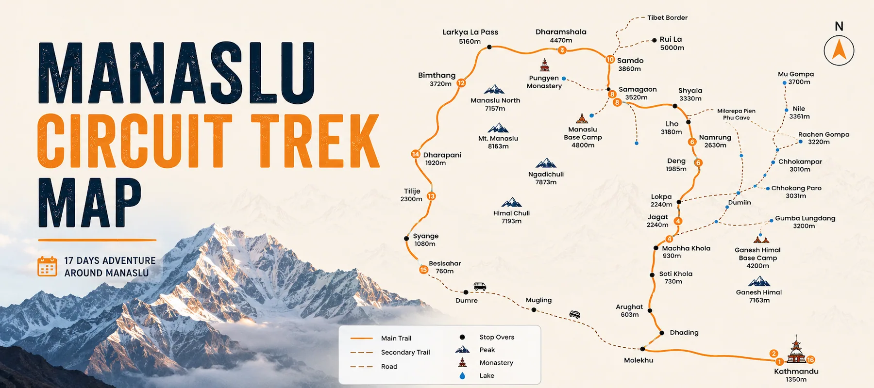
This is the Manaslu Circuit Trek Map, which is a visual guide to one of Nepal’s most remote and challenging trekking routes in Nepal.
The Official Manaslu Circuit Trek Map displays,
Many trekkers don’t study the map beforehand and sometimes get into trouble due to mistakes.
What the map tells you:
The complete Manaslu Circuit Trek Map route in one overview:
Days 1-2: Kathmandu
Days 3-5: Kathmandu to Machha Khola
Days 6-9: Machha Khola to Samdo
Days 10-11: Samdo Rest & Larke La Pass
Days 12-14: Larke La to Bimthang
Days 15-17: Bimthang to Kathmandu
Total elevation gain: Approximately 3,850m total (up and down)
Total elevation loss: Approximately 3,850m total
Hardest climbing: Days 6-10 (daily gains of 600-800m)
Easiest days: Days 1-2, 15-17 (city, vehicle travel)
The altitude chart on the Manaslu Circuit Trek map shows elevation changes throughout 17 days.
Vertical axis: Height in meters (0m to 6,000m) Horizontal axis: Days (1 through 17)
Color-coded locations:
Days 1-5: Mostly flat, slight ups and downs
Days 6-9: Steep uphill climb
Day 10: Slight up, return down
Day 11: Steep climb to peak
Day 12: Sharp descent
Days 13-14: Gradual descent
Days 15-17: Return journey
| Altitude | Effects | Days |
| 0–2,000m | Warm temperatures and comfortable breathing. | Days 1–5, 15–17 |
| 2,000–3,000m | Cooler weather with mild breathlessness during exertion. | Days 6–8 |
| 3,000–4,000m | Cold nights and noticeably thinner air. | Days 8–10 |
| 4,000–5,000m | Very cold conditions with an increased risk of altitude sickness. | Days 11–12 |
| Above 5,000m | Extreme altitude with very thin air; immediate descent is necessary if serious altitude sickness develops. | Day 11 (Larke La Pass) |
Understanding the map means knowing the towns where you’ll sleep.
| Day | Location | Altitude | Accommodation | Highlights |
| 3 | Dhodding | 1,440m | Tea House | Gateway to the Manaslu mountain region. |
| 4 | Arughat | 603m | Tea House | Scenic river crossings and village landscapes. |
| 5 | Machha Khola | 930m | Lodge | Official entry into the Manaslu trekking region. |
| 6 | Deng | 1,988m | Tea House | Steeper ascents begin as the trail gains elevation. |
| 7 | Namrung | 2,630m | Tea House | Traditional Tibetan-influenced villages and culture. |
| 8 | Lho | 3,180m | Lodge | Magnificent views of Manaslu and surrounding peaks. |
| 9 | Samdo | 3,875m | Basic Lodge | High-altitude settlement with colder temperatures. |
| 10 | Samdo | 3,875m | Basic Lodge | Acclimatization day to prepare for higher elevation. |
| 11 | Larke La Pass | 5,160m | Emergency Shelter (if needed) | Highest point of the trek with challenging alpine conditions. |
| 12 | Bimthang | 2,590m | Tea House | Long descent brings warmer temperatures and recovery. |
| 13 | Bimthang | 2,590m | Tea House | Rest day surrounded by beautiful Himalayan scenery. |
| 14 | Dharamshala | 1,920m | Tea House | Gentler trekking through forests and valleys. |
| 15 | Besisahar | 760m | Hotel | Return to lower altitude and conclude the trek. |
From the map, these are the major peaks visible:
| Peak | Altitude | Best Viewing Period | Visible From |
| Mt. Manaslu | 8,163m | Throughout the trek | North / West |
| Manaslu North | 7,157m | Days 6–11 | North |
| Ganesh Himal | 7,693m | Days 13–14 | South |
| Unnamed Peaks | 6,000m+ | Various days | Along the trekking route |
| Himalayan Range | 6,000–8,000m | Days 6–11 | Surrounding mountain panorama |
If you want to study the Manaslu map before trek:
Alliance Treks Map (provided with trek package)
Google Maps (offline)
Maps.me
Garmin BaseCamp
AllTrails
Komoot
Yes. Your licensed guide will handle navigation throughout the trek. However, understanding the route map helps you prepare mentally, anticipate daily elevation changes, and better appreciate the journey.
Days 6–9 involve continuous elevation gain and increasing altitude, while Day 11, when crossing Larke La Pass (5,160m), is the most demanding day of the entire Manaslu Circuit Trek.
Yes. Download offline maps before your trek using Google Maps, Maps.me, Gaia GPS, or AllTrails, as mobile coverage is limited in remote sections of the trail.
Your guide will assess the situation and use approved alternative trails whenever they are safe and open. Route changes are occasionally necessary due to landslides, snow, or trail maintenance.
The official Alliance Treks route map is regularly updated and provides reliable navigation information. Older printed trekking maps may contain outdated trail or accommodation details.
No. Trekkers should remain on the designated Manaslu Circuit route. Leaving the main trail can be dangerous and may violate restricted-area trekking regulations.
Larke La Pass (5,160m) is the highest and most challenging point of the trek. It is crossed on Day 11 and requires an early start, favorable weather, and proper acclimatization.
Yes. You can view the digital route map on the Alliance Treks website or request a printed map when confirming your trek booking.
No. Larke La Pass is the only crossing that completes the Manaslu Circuit. If conditions become unsafe, trekkers normally return via the same route.
The complete 17-day trek involves approximately 3,850 meters of cumulative elevation gain and a similar amount of descent.
Alliance Treks & Expedition Pvt. Ltd. Once is not enough for naturally and culturally Himalayas