(Viber, Whatsapp, Cell) +977 9851022814

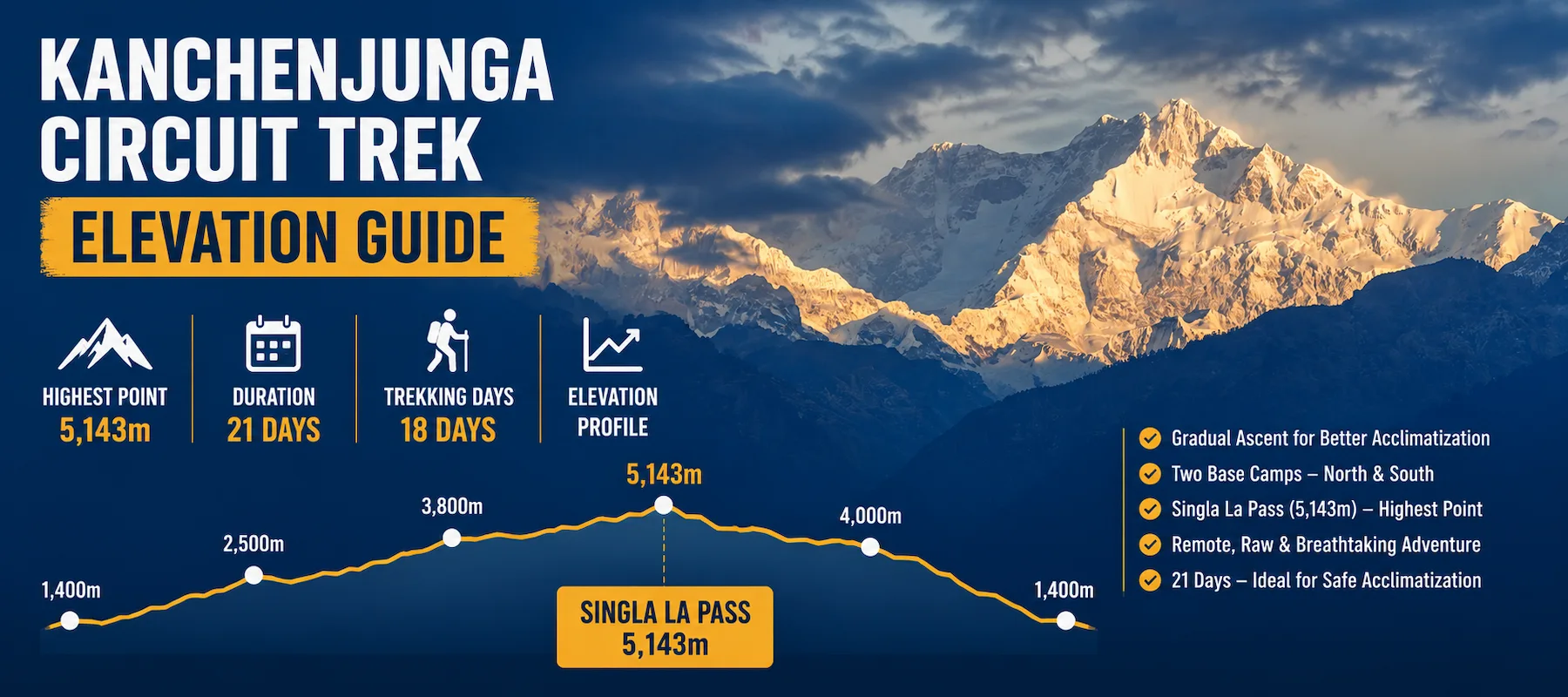
The simple facts:Hiking: 4-5 days
Highest point: Singla La Pass at 5,143m (16,873 feet)
Duration: 21 days total, with 18 days of actual trekking
Elevation gain pattern: Gradual ascent from 1,400m to 4,780m over 8 days, then remaining at high altitude (4,000-5,143m) for 7 days, then descent over 5 days
Maximum single-day gain: About 1,330m on Day 7 (Gyapla to 4,050m, cumulative gain)
Acclimatization built in: Designated acclimatization day at Ghunsa (Day 9); natural acclimatization through gradual ascent and two high-altitude base camps
Key advantage: The 21-day duration allows exceptional acclimatization time compared to shorter treks
Unique factor: Two base camps (North and South) mean you experience high altitude multiple times, reinforcing acclimatization
Remote challenge: Eastern Nepal location means less developed infrastructure, slower rescue response, more extreme isolation
Kanchenjunga Circuit Trek elevation is different in comparison to the other major Nepal treks. Understanding these differences will help for your preparation.
First: The duration is the longest. At 21 days, Kanchenjunga is the longest trek you will cover (compared to Manaslu’s 17 days, Upper Mustang’s 15 days, Ghorepani’s 9 days).
More days means it requires better acclimatization to properly adapt to its elevation, for your body has 14+ days to gradually adapt to high altitude before reaching Singla La Pass. This extended timeline is your advantage—the 5,143m elevation is more manageable with this much acclimatization time.
Second: Eastern Nepal location changes everything. Kanchenjunga sits in the far eastern Himalaya, closer to the Indian border. This location means:
The remoteness is part of authentic Nepal but also it means higher risk if something goes wrong.
Third: Two base camps mean high-altitude stays. Most treks have one high point you reach and descend from. Kanchenjunga has:
You experience extreme altitude twice, reinforcing your body’s acclimatization and making the third-highest mountain’s environment deeply familiar.
Fourth: The ascent is dramatically gradual. You don’t jump to altitude. You start at 1,400m (Kathmandu), descend to 980m (Sinuwa), then ascend slowly: Days 3-4: 980m to 2,725m (average 872m daily) Days 5-8: 2,725m to 4,780m (average 675m daily) Days 9-11: Acclimatization and high-altitude stays
This gentle pace is why altitude sickness is manageable, despite the 5,143m maximum.
Here’s the complete day-by-day elevation breakdown for Kanchenjunga Circuit Trek:
| Day | From | To | Elevation | Daily Gain/Loss | Cumulative From Start | Activity |
| 1 | Kathmandu | Kathmandu | 1,350m | 0m | 0m | City, preparation |
| 2 | Kathmandu | Birtamode | ~900m | -450m | -450m | Drive only |
| 3 | Taplejung (1,820m) | Sinuwa | 980m | +180m | -270m | Trek starts |
| 4 | Sinuwa | Taplethok | 2,725m | +1,745m | +1,475m | Steep ascent |
| 5 | Taplethok | Sekathum | 3,451m | +726m | +2,201m | High altitude begins |
| 6 | Sekathum | Amjelasa | 3,451m | 0m | +2,201m | Gentle walking |
| 7 | Amjelasa (2,308m) | Gyapla | 4,050m | +1,742m | +3,943m | Major ascent |
| 8 | Gyapla | Ghunsa | 4,780m | +730m | +4,673m | High-altitude trek |
| 9 | Ghunsa | Ghunsa | 4,780m | 0m (Rest) | +4,673m | Acclimatization |
| 10 | Ghunsa | Khambachen | 4,050m | -730m | +3,943m | Gradual descent |
| 11 | Khambachen | Lhonak | 4,780m | +730m | +4,673m | Return to high altitude |
| 12 | Lhonak | North Kanchenjunga Base Camp | 5,143m | +363m | +5,036m | Highest point |
| 12 | North Kanchenjunga Base Camp | Lhonak | 4,780m | -363m | +4,673m | Return trek |
| 13 | Lhonak | Ghunsa | 4,780m | 0m | +4,673m | Retrace route |
| 14 | Ghunsa | Selela Base Camp | 4,130m | -650m | +4,023m | Descent begins |
| 15 | Selela Base Camp | Ramche | 4,630m | +500m | +4,523m | Pass crossing |
| 16 | Ramche | Cheram (South BC area) | 3,860m | -770m | +3,753m | Descending |
| 17 | Cheram | Trongding | 3,590m | -270m | +3,483m | Lower elevation |
| 18 | Trongding | Yambudin | 2,065m | -1,525m | +1,958m | Major descent |
| 19 | Yambudin | Gopetar | 2,065m | 0m | +1,958m | Easy trekking |
| 20 | Gopetar | Birtamode | ~900m | -1,165m | +793m | Drive |
| 21 | Birtamode | Kathmandu | 1,350m | +450m | +1,243m | Drive return |
Singla La Pass is the highest point in Kanchenjunga Circuit Trek and it’s defining elevation feature. Understanding it is essential.
A high-altitude mountain pass at 5,143m (16,873 feet), separating two valleys in the eastern Himalaya. It’s part of the Kanchenjunga Circuit’s classic route and is the highest point of the trek.
At 5,143m, Singla La Pass sits in extreme altitude territory:
The elevation context:
At 5,143m, you’re at the limit of acclimatization for most trekkers. Oxygen is roughly 50% of sea-level availability. Many people experience moderate to severe altitude sickness.
But here’s the critical difference: You reach this elevation after 12 days of acclimatization (compared to Larke La’s 11 days). That extra day matters significantly.
The pass crossing itself:
Day 12 involves:
What the ascent feels like:
Temperature and conditions:
At Singla La Pass:
Most trekkers cross the pass in the morning to maximize clear weather and descent before cold afternoon wind.
Safety at Singla La Pass:
Unlike Larke La Pass (Manaslu), Singla La Pass is not technically difficult. There’s no rock climbing or rappelling. The danger is purely altitude-based:
With proper acclimatization (the 12-day ascent), most healthy trekkers safely cross.
Kanchenjunga’s unique feature is visiting two base camps, North and South. This affects your elevation experience dramatically.
North Base Camp (Day 12):
Elevation: 5,143m
Access: Day trip (excursion) from Lhonak (4,780m)
Climb: 363m elevation gain Purpose: Get closest to Kanchenjunga’s north face
Time: Full day (12-14 hours round trip) Experience: Extreme altitude, glaciated terrain, mountain-focused
At North Base Camp, you’re at peak elevation, surrounded by the mountain’s north face. Snow, ice, and rock dominate the landscape. The experience is extreme and brief, you don’t sleep here, just a day-trip from Lhonak.
South Base Camp (Days 15-16):
Elevation: ~4,130m (lower than North Base Camp but still high)
Access: Multi-day trek from Ramche and Cheram
Climb: Gradual ascent over 3+ days
Purpose: View Kanchenjunga’s south face and access point to the mountain
Time: 2-3 days in the area Experience: Lower altitude than North BC, but sustained high-altitude stay
South Base Camp feels different, it’s more of a camp/settlement (active mountaineering base) rather than North Base Camp’s remote wilderness. You spend more time here, acclimatizing further.
Why two base camps matter for acclimatization:
Visiting two base camps reinforces your body’s altitude adaptation:
This up-down-up pattern—”sawtooth elevation”—is actually beneficial for acclimatization. Each ascent triggers adaptation responses. The descents allow partial recovery. Your body becomes progressively more adapted.
Compared to single-base-camp treks (Larke La Pass, Everest BC) where you reach a high point once and descend. Kanchenjunga’s two-base-camp structure is superior for acclimatization physiologically.
Your body experiences different effects at different elevations on the 21-day trek.
Sea Level to 1,500m (Days 1-2):
Kathmandu (1,350m) and the starting elevation. Your body feels normal. No altitude effects. This is the pre-trek adjustment phase.
1,500m to 2,500m (Days 3-4):
Sinuwa (980m) to Taplethok (2,725m). Ascending into moderate altitude. Your body starts working:
Most trekkers feel fine here—they just notice they’re working a bit harder than normal.
2,500m to 3,500m (Days 5-6):
Taplethok to Amjelasa (3,451m). Clear altitude effects start:
This is where many trekkers first think “I feel altitude.” But the effects are manageable. Your body is adapting.
3,500m to 4,500m (Days 7-11):
Gyapla to Ghunsa to high altitude areas. Serious altitude effects develop:
This is the challenging altitude band. Your body is under real stress. The acclimatization day at Ghunsa (4,780m) is critical here—your body needs a full day without additional elevation to adapt.
Above 4,500m (Days 12-16):
Singla La Pass area and South Base Camp. Extreme altitude:
This is where most altitude sickness symptoms are severe. But because your body has 12+ days of acclimatization, symptoms are typically moderate rather than dangerous.
The critical difference: After 12 days of gradual ascent, severe altitude sickness (HACE/HAPE) is rare. After rushing upward (Everest BC in 6 days), severe sickness is common.
The 21-day duration allows exceptional acclimatization. Understanding the strategy helps you appreciate why the trek is structured this way.
Days 1-2: Sea-Level Adjustment
Pre-trek transportation and preparation. Your body is at sea-level baseline.
Days 3-4: First Ascent Phase (980m to 2,725m)
Gentle ascent to moderate altitude. Your body starts adapting. No special acclimatization needed—the pace (average 872m daily) is conservative.
Days 5-8: Second Ascent Phase (2,725m to 4,780m)
Continued gradual ascent to high altitude. Average gain: 675m daily. Slower than mountaineering standards (which suggest max 400-500m daily above 3,000m), but the itinerary respects this by spreading it over 4 days.
The slow pace allows your body to make physiological changes:
Day 9: Critical Acclimatization Day
Ghunsa (4,780m). You stay at the same elevation. No additional gain. This is when adaptation happens most intensely.
On this day, many guides recommend optional acclimatization hike to nearby peaks (4,900-5,000m), then return to Ghunsa to sleep. This “climb high, sleep low” principle is gold standard for acclimatization:
Your body experiences 5,000m altitude, starts adapting, then recovers at 4,780m where sleep is more achievable.
Days 10-13: High-Altitude Plateau
Khambachen (4,050m) to Lhonak (4,780m) North Base Camp excursion to return. You stay in this altitude band for 4 days, rotating between 4,000-5,143m.
This rotation—moving between different high elevations for several days—is exceptional for acclimatization. Your body becomes progressively adapted to extreme altitude through repeated exposure and recovery.
Days 14-19: Descent Phase
Gradual descent from 4,130m to 2,065m over 6 days. Descent is usually easier than ascent because oxygen increases with every step downward. Recovery accelerates as elevation decreases.
Interestingly, many trekkers report:
These sudden improvements confirm that altitude sickness was the cause—not fitness issues or illness.
Days 20-21: Return to Sea Level
Drive back to Kathmandu (1,350m). Your body is back at starting elevation. Recovery is complete, though some trekkers report mild fatigue from the overall 21-day exertion.
Altitude sickness on Kanchenjunga is more likely than on other treks, primarily because:
Altitude sickness types:
Acute Mountain Sickness (AMS): Most common. Symptoms:
Affects roughly 40-50% of Kanchenjunga trekkers above 4,000m.
High Altitude Cerebral Edema (HACE): Severe, rare. Brain swelling. Symptoms:
Affects roughly 1-2% of Kanchenjunga trekkers. Requires immediate descent.
High Altitude Pulmonary Edema (HAPE): Severe, rare. Fluid in lungs. Symptoms:
Affects roughly 0.5-1% of Kanchenjunga trekkers. Requires immediate descent.
Why Kanchenjunga has higher AMS rates:
Prevention:
Rescue reality:
On Kanchenjunga, if you experience severe altitude sickness:
This is why prevention is critical. You don’t want to need rescue in remote eastern Nepal.
Key daily insights:
Steepest single day: Day 4 (Sinuwa to Taplethok): +1,745m gain
Longest cumulative gain: Days 5-8 (staying in 3,500-4,780m band)
Most challenging section: Days 7-11 (high altitude sustained)
Longest descent: Days 18-19 (Trongding to Yambudin)
At 1,350m (Kathmandu):
Normal. You’re at the starting baseline. Energy is high and sleep will be good.
At 2,725m (Taplethok, Day 4):
You feel the ascent physically but manage fine. Breathing is slightly faster on uphill. You sleep well. The following day you feel recovered.
At 3,451m (Sekathum/Amjelasa, Days 5-6):
Altitude is becoming noticeable. Uphill breathing is definite. Sleep is good but maybe disrupted once. You might have a mild headache (though could be from physical exertion, not altitude). Energy is good.
Common thought: “I feel altitude but it’s manageable.”
At 4,050m-4,050m (Gyapla, Day 7):
Real altitude now. Walking uphill feels hard—not from fitness, but from air thinness. Your legs tire because your muscles need more oxygen. Every 100 meters of elevation gain feels significant.
The temperature is noticeably cool (10-15°C) even during the day. Wind is present.
Sleep is definitely disrupted. You wake 2-3 times, sleep maybe 5-6 hours total. You might have a mild headache (common at this elevation).
Appetite might be slightly reduced. Food doesn’t taste as good. Eating feels like a chore.
Common thought: “Altitude is real now. I’m managing but I’m definitely not as comfortable.”
At 4,780m (Ghunsa, Days 8-9):
High altitude stress is obvious. Everything physical is exaggerated. Walking at a normal pace is actually difficult—you’re working hard but moving slowly. Your heart pounds constantly. Breathing is rapid and deep.
The temperature is cold (5-10°C daytime, -5°C nighttime). Wind is present. The sky is often clearer at this elevation (you’re above many clouds).
Sleep is poor. You might sleep 3-4 hours total. You wake frequently, feeling restless. You might experience vivid dreams or nightmares (common at altitude).
Appetite is noticeably reduced. Some trekkers eat barely half their normal amount. Food might taste metallic or unpleasant.
Headache is possible (maybe 30-40% of trekkers). It’s usually mild to moderate—managed with ibuprofen.
Nausea is possible (maybe 20-30% of trekkers). Not vomiting usually, but uncomfortable.
You might feel confused or “brain fog”—not severe, but thinking is slightly slow. Simple math is harder. Making decisions takes more effort.
Some trekkers experience mild euphoria (altitude high from adrenaline and endorphins). Others experience mild depression or emotional sensitivity.
Common thought: “This is seriously high altitude. My body feels stressed. The acclimatization day is welcome.”
At 5,143m (Singla La Pass, Day 12):
Extreme altitude. Everything is magnified from Ghunsa. Physical exertion is severe—walking feels almost unbearable. Your heart pounds constantly. You’re breathing hard at all times.
Mentally, you’re operating at reduced capacity. Thinking is slow. Decision-making is difficult. You might experience confusion or disorientation.
Headache is likely. It might be moderate to severe. Ibuprofen helps but doesn’t eliminate it.
Nausea is possible. Some trekkers feel genuinely unwell.
Coordination might be slightly off—your balance is normal, but everything feels sluggish.
But here’s the critical thing: Because you’ve had 12+ days of acclimatization, severe altitude sickness is rare. Most trekkers manage at this elevation, though they’re definitely uncomfortable.
Common thought: “This is the hardest physical experience of my life. But I can do it. My guide is confident. I’m managing.”
Comparing elevation and altitude sickness risk across treks:
| Trek | Max Elevation | Days to Max | Acclimatization Days | Altitude Sickness Risk | Remote Factor | Kanchenjunga Comparison Insights |
| Ghorepani Poon Hill | 3,210m | 4 days | 0 | 5% | Low | Much easier and lower than Kanchenjunga. Ideal for beginners with minimal altitude concerns. |
| Upper Mustang | 3,810m | 8 days | 0 (built-in gradual ascent) | 15% | High | Less physically demanding than Kanchenjunga, but still remote. Lower altitude means fewer altitude-related issues. |
| Manaslu Circuit | 5,160m | 11 days | 2 days | 50% | Medium–High | Similar altitude to Kanchenjunga but shorter. Manaslu crosses a high pass, while Kanchenjunga involves longer exposure at high elevation. |
| Kanchenjunga Circuit | 5,143m | 12 days | 1 day + multiple high-altitude nights | 45% | Very High | The most remote major tea house trek in Nepal. Longer duration, sustained high-altitude exposure, and excellent acclimatization make it physically demanding but rewarding. |
| Everest Base Camp | 5,364m | 6 days | 0 dedicated | 55% | Medium | Higher maximum altitude than Kanchenjunga and reached more quickly, resulting in a slightly higher risk of altitude sickness despite better infrastructure. |
Kanchenjunga’s unique position:
Preparing for Kanchenjunga requires more than typical high-altitude trek prep because of remoteness.
Physical Training (12+ weeks before):
Goal: Comfortably hike 5+ hours uphill at moderate intensity.
Altitude Training:
Medication Consultation:
Discuss with doctor:
Equipment Essentials (Critical in remote area):
Mental Preparation:
Kanchenjunga North Base Camp (Pangpema) sits at 5,143m (16,873 feet) above sea level. For comparison, commercial aircraft fly above 35,000 feet, but cabin pressure is maintained at roughly 8,000 feet, making Pangpema significantly higher than that equivalent altitude.
Both treks reach nearly the same maximum elevation (Kanchenjunga: 5,143m, Manaslu: 5,160m). However, Kanchenjunga has a longer itinerary with better acclimatization, making the altitude easier to adapt to despite its greater remoteness and overall duration.
Yes. Mild Acute Mountain Sickness (AMS) affects around 40–50% of trekkers, while severe conditions such as HACE and HAPE are uncommon but possible. The trek’s gradual ascent and acclimatization schedule significantly reduce the risk when followed properly.
Kanchenjunga is one of Nepal’s most remote trekking regions. Rescue operations may take 24–48 hours, and medical facilities are limited. Trekking with an experienced guide, proper preparation, and preventive measures is essential for safety.
The standard 21-day itinerary includes around 12 days of gradual ascent, one dedicated acclimatization day, and several nights above 4,000m. This schedule helps your body adapt safely before reaching the highest point.
Consult your doctor before the trek. Some travelers use Diamox (acetazolamide) to help prevent altitude sickness, while others rely on gradual acclimatization. Your doctor can recommend the safest approach based on your medical history.
Inform your guide immediately. Mild symptoms such as headache or nausea should be monitored closely. Severe symptoms—including confusion, loss of coordination, or difficulty breathing—require immediate descent, which is the most effective treatment.
Yes. While some itineraries visit only the North Base Camp, trekking to both the North and South Base Camps offers a more complete experience, improves acclimatization, and showcases the diverse landscapes of the Kanchenjunga Conservation Area.
Kanchenjunga Circuit Trek’s 5,143m Singla La Pass is achievable for most healthy, well-prepared trekkers. The 21-day duration with built-in acclimatization is your advantage.
The elevation is extreme but manageable. At 5,143m, you’re at a serious altitude. But 12+ days of gradual ascent means your body has adapted.
The remoteness is the real challenge. Eastern Nepal lacks infrastructure and rescue is slow. You need to be self-sufficient, well-prepared, and honest with your guide about symptoms.
The acclimatization strategy is superior. More days means better adaptation. The designated acclimatization day and two base camp systems reinforce your body’s acclimatization in ways shorter treks cannot.
Success depends on preparation and listening to your guide. Trekkers who follow the itinerary, stay hydrated, communicate symptoms early, and trust their guides have high success rates. Trekkers who rush, hide symptoms, or push beyond their ability have higher rates of serious problems.
Kanchenjunga is genuinely challenging. It’s one of Nepal’s most remote and difficult treks. But after 21 days and 5,143m of elevation, you’ll have achieved something genuinely extraordinary.
Alliance Treks & Expedition Pvt. Ltd. Once is not enough for naturally and culturally Himalayas