(Viber, Whatsapp, Cell) +977 9851022814

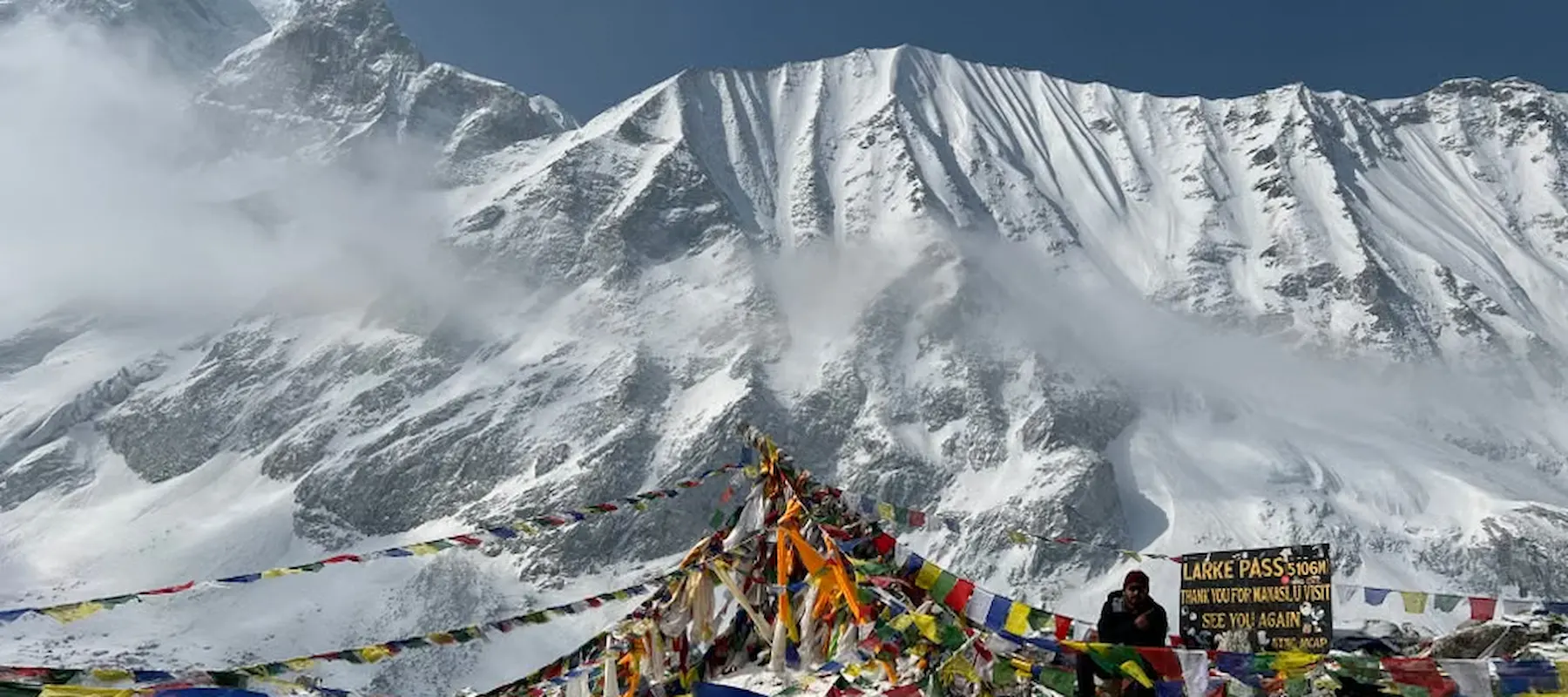
The Larkya La Pass crossing is a single 8 to 10 hour day from Dharamsala (about 4,460 m) over the pass (about 5,106 m) and down to Bimthang (about 3,600 to 3,720 m). You start in the dark, between 3:00 and 4:00 AM, climb roughly 650 to 700 m, then lose about 1,400 to 1,500 m on the way down. There is no technical climbing, but altitude, cold, length, and a knee-punishing descent make it the hardest day of the Manaslu Circuit.
This guide covers what actually happens on pass day: the numbers, an hour-by-hour plan, the decision rules your guide will use, what to wear and eat, the warning signs of altitude sickness, and how to prepare so the day is hard but manageable.
| Detail | Information |
|---|---|
| Pass altitude | About 5,106 m (16,752 ft) |
| Starts at | Dharamsala (Larkya Phedi), about 4,460 m |
| Ends at | Bimthang, about 3,600 to 3,720 m |
| Climb to the pass | About 650 to 700 m |
| Descent to Bimthang | About 1,400 to 1,500 m |
| Distance | About 24 to 25 km |
| Time | 8 to 10 hours |
| Typical start | 3:00 to 4:00 AM |
| Technical skill | None (no ropes or ice axes), but snow and ice are common |
| Best seasons | September to November, March to May |
About the altitude: Sources disagree. 5,106 m is the most widely cited figure. Many operators, including Alliance Treks, list 5,160 m. Dharamsala is given as 4,460 or 4,480 m, and Bimthang as 3,590 or 3,720 m. These are measurement and rounding differences, not different places. Plan for roughly 5,100 m and treat the exact digits as approximate.
| Factor | Why it matters |
|---|---|
| Altitude | You spend hours above 4,800 m, where every step takes more effort and decision-making slows |
| Cold | The start is in the dark, and temperatures at dawn can fall well below freezing (some operators cite about -15°C) |
| Length | It’s a full day of 8 to 10 hours, often 24 to 25 km, with few places to shelter |
| Terrain | Steep rocky climbing, moraine (loose glacial rubble) and often snow or ice patches |
| The descent | Dropping about 1,400 m on tired legs is where many people feel the day most |
| Weather | Wind and cloud tend to build later in the morning, which is why the start is so early |
The pass is hard because all of these combine in one day, not because any single part is extreme. That is also why preparation works: good acclimatization, a steady pace and the right gear take much of the sting out of it.
Your body’s adjustment over the days before pass day matters more than anything you do on the morning itself. On Alliance Treks’ 17-day plan, the build-up looks like this:
| Day | Sleeping altitude (approx.) | Purpose |
|---|---|---|
| Namrung | 2,630 m | Steady climbing into Tibetan-influenced villages |
| Samagaun (2 nights) | 3,530 m | Rest day with a hike to Manaslu Base Camp or Birendra Lake |
| Samdo (2 nights) | 3,865 m | Rest day with a ridge walk toward the Tibet border |
| Dharamsala | 4,460 m | Short day, staging for the pass |
Use the rest days properly: hike high, sleep low, drink plenty of water and avoid alcohol. The 17-day plan uses both rest days for acclimatization and has no spare weather day on the trail, so if you want a buffer for snow or wind, ask your operator about adding one.
Dharamsala is a basic stone shelter, not a comfortable lodge. Expect early dinner (often around 5:00 to 6:00 PM), cold rooms, thin air and poor sleep, which is normal at this height. Monitor how you feel.
| Item | Check |
|---|---|
| Headlamp with fresh batteries (and a spare) | Needed for the first two to three hours |
| Water | Fill bottles, use insulated sleeves, keep them inside your pack so they don’t freeze |
| Snacks | Easy-to-eat food, such as chocolate, nuts, energy bars, in an outer pocket |
| Layers | Lay out base, mid and shell layers, hat, gloves, buff, sunglasses |
| Traction | Microspikes or light crampons if conditions call for them |
| Health | Tell your guide about any headache, nausea, breathlessness or unusual tiredness |
| Phone and power bank | Keep warm in an inner pocket |
| Documents | Permits and passport in a waterproof pouch |
This is a typical pattern, not a schedule. Your guide sets the actual timing based on weather, snow and how the group is feeling.
| Time (approx.) | Section | What happens |
|---|---|---|
| 2:30 to 3:00 AM | Wake up | Hot tea or breakfast, last gear check |
| 3:30 to 4:00 AM | Leave Dharamsala | Headlamps on, steady slow pace on a steep first climb |
| 4:00 to 6:30 AM | Climb and moraine | Steep rocky ground, then a long stretch over glacial moraine, with the first light arriving |
| 7:30 to 9:00 AM | Pass summit | Prayer flags, panorama, a brief rest (do not linger, it’s cold and windy) |
| 9:00 to 11:00 AM | Upper descent | Snow, ice or loose rock; the steepest and most technical-feeling part of the way down |
| 11:00 AM to 12:30 PM | Lower descent | Slopes ease into grass and a long, steady drop |
| 1:00 to 3:00 PM | Arrive at Bimthang | Warm meal, a real bed and the end of the hardest day |
From the pass you’ll usually see Himlung Himal, Cheo Himal, Kang Guru and Annapurna II, a view that spans two major ranges.
Your guide makes the final call. These are the factors licensed guides typically weigh, and it helps to know them so the decision doesn’t surprise you.
| Condition | What it usually means |
|---|---|
| Headache with nausea, unsteady walking, confusion or breathlessness at rest | Do not go higher. Descend and rest. |
| Heavy new snow, whiteout or poor visibility | Delay a day if you have one, or turn back |
| Strong winds near the pass | A common reason to delay or abort, as wind chill adds real risk |
| Falling behind schedule (for example, not near the pass by about 9:30 to 10:00 AM) | Discuss turning back, as conditions worsen later |
| Pass officially closed | Do not attempt it |
| Someone in the group is struggling | The group moves at the slowest person’s pace, or splits with a guide for |
Turning back is not failure. Pass-day accidents tend to come from pushing on despite symptoms or weather.
Many trekkers find the descent harder than the climb. You drop about 1,400 to 1,500 m over several hours, first over snow, ice or loose rock, then down steep slopes toward the meadow of Bimthang. Fatigue and altitude make footing less sure.
| Level | Signs | What to do |
|---|---|---|
| Mild | Headache, nausea, tiredness, poor sleep | Stop, rest, hydrate, tell your guide, do not go higher until symptoms improve |
| Moderate | Worsening headache, vomiting, dizziness, loss of appetite | Descend. Do not continue over the pass. |
| Severe (emergency) | Confusion, loss of coordination, breathlessness at rest, wet cough | Descend immediately, with help, and arrange evacuation |
Some trekkers take acetazolamide (Diamox) after talking to a doctor, but it doesn’t replace acclimatization and isn’t a reason to push on with symptoms. For symptoms, prevention and when to descend, see our guide to altitude sickness. Your insurance should cover trekking to at least 5,500 m and helicopter evacuation.
| Category | Key items |
|---|---|
| Layers | Thermal base layer, fleece or light down mid-layer, waterproof and windproof shell |
| Extremities | Warm hat, buff or balaclava, liner and insulated gloves, warm socks |
| Traction | Microspikes (lightweight) and gaiters if there’s snow |
| Eyes and skin | High-UV sunglasses or goggles, sunscreen, lip balm with SPF |
| Light | Headlamp and spare batteries |
| Support | Trekking poles, which matter most on the descent |
| Fuel | Water (insulated), snacks, electrolyte mix, thermos of hot tea |
| Backup | Small first-aid kit, hand warmers, spare gloves |
Carry a small, light pack. Your porter takes the rest of your gear to Bimthang.
| Weeks before | Focus | Example |
|---|---|---|
| 12 to 16 | Cardio base | 3 to 4 sessions a week of walking, running or cycling |
| 8 to 12 | Hills and strength | Weekly hill or stair sessions with a loaded daypack, plus squats and lunges |
| 4 to 8 | Long days | One 5 to 7 hour hike a week in your trek boots |
| 2 to 4 | Downhill | Practice descending stairs or steep slopes to strengthen your legs |
| Final week | Rest | Light walking, check gear and documents |
Downhill practice is the training most people skip, and the descent is where it pays off.
| Feature | Larkya La (Manaslu Circuit) | Thorong La (Annapurna Circuit) |
|---|---|---|
| Altitude | About 5,106 m (some sources 5,160 m) | 5,416 m |
| Pass day distance | About 24 to 25 km | About 16 km |
| Pass day length | 8 to 10 hours | 8 to 10 hours |
| Terrain | Moraine, steep rock, snow patches | Wide trail, long open climb |
| Lodging before the pass | Basic shelter at Dharamsala | Lodges at Thorong Phedi |
| Crowds | Few trekkers | Many trekkers |
| Support if something goes wrong | Remote, limited | Better road and lodge access |
Thorong La is higher. Larkya La is longer, more remote and has fewer comforts. Neither is technical, but both demand real fitness and respect for altitude.
| Season | Months | Pass conditions |
|---|---|---|
| Autumn | September to November | Most stable weather and the most common season; October and November are generally the most reliable months |
| Spring | March to May | Good, but snow may remain and weather can change quickly |
| Winter | December to February | Heavy snow and extreme cold can make the pass impassable |
| Monsoon | June to August | Rain and landslide risk in the lower valley; poor visibility |
The Larkya La is in a restricted area. You need the Manaslu Restricted Area Permit, MCAP, ACAP, a local municipality permit and a TIMS card, and a licensed guide is mandatory. A registered agency arranges the permits. See the Manaslu Circuit Trek page and our guide to mandatory guides in Nepal. Because the route is closed after the October 11 flood, permits are not being used for the circuit right now.
About 5,106 m (16,752 ft) by the most widely cited figure. Some operators, including Alliance Treks, list 5,160 m, and measurements vary.
Typically 8 to 10 hours from Dharamsala to Bimthang, starting between 3:00 and 4:00 AM.
It’s challenging and non-technical. The difficulty comes from altitude, cold, length and a long, steep descent.
Thorong La is higher, while Larkya La is longer, more remote and has more basic facilities. Many trekkers find Larkya La physically tougher overall.
Most groups leave Dharamsala between 3:00 and 4:00 AM so they reach the pass in the morning, before the wind strengthens.
Not always. Microspikes or light crampons are recommended when there is snow or ice, which is common, and your guide will advise on the day.
Fit first-timers with a hiking background and a proper acclimatization schedule can, but it’s a demanding objective. A shorter trek first is a sensible step for people with no prior trekking.
Guides delay a day if the schedule allows, or turn back. Heavy snow can close the pass for days, which is why a spare weather day is worth asking for.
No. After the October 11, 2026 Budhi Gandaki flood, the route is closed to trekkers, and no reopening date has been announced. Confirm with a licensed operator.
Autumn (September to November) and spring (March to May), with October and November usually the most reliable.
At Dharamsala (Larkya Phedi), about 4,460 m, a basic stone shelter.
Practice downhill walking in your training, use trekking poles and keep drinking and eating through the descent.
The Larkya La is the moment the Manaslu Circuit has been building toward, and it asks for patience more than heroics. Acclimatize well, start early, move slowly, respect the go or no-go rules, and look after your knees on the way down. With the Manaslu route currently closed after the October 11 flood, this is a good time to plan: train for the descent, check your gear, and ask your operator how they handle weather days.
Alliance Treks & Expedition Pvt. Ltd. runs a 17-day Manaslu Circuit with two acclimatization days, a licensed guide, a porter shared between two trekkers and all restricted-area permits. Departures depend on the route reopening, so contact the team for the latest status and alternatives such as the Annapurna Circuit and its Thorong La crossing.
Alliance Treks & Expedition Pvt. Ltd. Once is not enough for naturally and culturally Himalayas