(Viber, Whatsapp, Cell) +977 9851022814

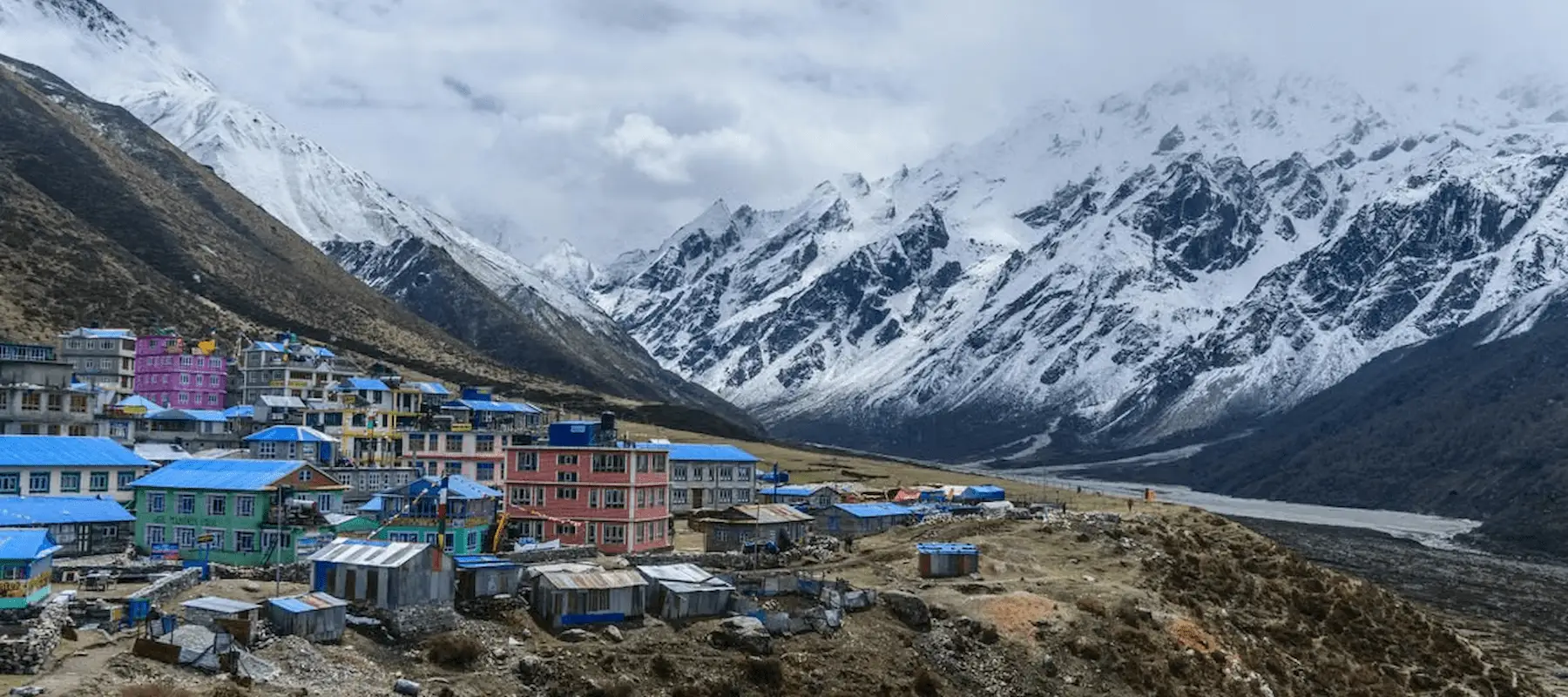
The Langtang Valley Trek is Nepal’s most convenient genuine Himalayan experience — a full mountain trek reachable by road in a single day from Kathmandu, without the flight dependency, permit restrictions, or crowds of Everest or Annapurna. Over 8 days, the route follows the Langtang River from the riverside town of Syabrubesi through rhododendron and bamboo forest, past a village rebuilt after the devastating 2015 earthquake, to Kyanjin Gompa at 3,870 meters — the spiritual and scenic heart of the valley, framed directly by Langtang Lirung (7,227 m).
This guide covers every stop along the trail in detail, the valley’s wildlife and vegetation, Tamang Buddhist culture and religious sites, local livelihoods, food and lodging, altitude and acclimatization planning, the best photography locations, essential gear, required permits, and honest answers to the questions trekkers ask most — including the current access situation following this year’s flooding.
“September 2026 access update: Following the August 26, 2026 flash flood near Rasuwa, the main Pasang Lhamu Highway remains blocked between Trishuli Bazaar, Betrawati, and Rasuwagadhi. Syabrubesi is currently reachable only via a slower, single-lane temporary detour through Tokha, Bidur, Nuwakot Durbar, Kalikasthan, and Ramche to Dhunche — expect longer, rougher travel days on the drive in. Importantly, the Langtang trekking trail itself, which climbs a separate valley east of Syabrubesi, was not damaged by the flood and remains intact from Syabrubesi through to Kyanjin Gompa. Confirm current road conditions with a licensed operator before departure, and build in extra buffer time for the drive.”
| Detail | Information |
|---|---|
| Duration | 8 days (Kathmandu to Kathmandu) |
| Max altitude | 5,033 m (Tserko Ri) / 4,773 m (Kyanjin Ri) |
| Starting/ending point | Kathmandu |
| Trip grade | Moderate |
| Group size | 1–15 |
| Transportation | Public bus |
| Accommodation | Teahouse/local lodge |
| Best seasons | Spring (March–May), Autumn (September–November), Winter (December–February) |
| Permits required | Langtang National Park Entry Permit, TIMS |
| Ethnic community | Tamang |
| Key highlight | Sunrise from Kyanjin Ri or Tserko Ri over Langtang Lirung |
Syabrubesi (1,500 m) — The Gateway
A scenic 7–8 hour drive from Kathmandu winds through hills, rivers, and terraced fields before arriving at Syabrubesi, a small riverside town that serves as the trailhead for Langtang, Gosaikunda, and the Tamang Heritage Trail alike. As the point most directly affected by this year’s regional flooding, it’s also where trekkers should expect the most noticeable change from pre-2026 trip reports — namely a longer, rougher drive in via the temporary detour route.
Lama Hotel (2,470 m) — Into the Forest
The trail follows the Langtang River through dense forest of oak, bamboo, and rhododendron, with genuine odds of spotting monkeys and forest birds along the way. Despite its name, Lama Hotel is a small cluster of lodges rather than a village, offering a peaceful overnight stop deep in the valley’s lower forest zone.
Langtang Village (3,430 m) — Rebuilt Resilience
As the trail climbs, the valley opens into stunning views of snow-capped peaks, passing traditional settlements and yak pastures. Langtang Village itself carries significant weight beyond its scenery — it was almost entirely destroyed by a massive landslide triggered by the 2015 Gorkha earthquake, and the village seen today has been rebuilt on the same site by returning Tamang families. It remains one of the largest and most historically significant settlements in the valley, and walking through it offers a genuine, sobering insight into local resilience.
Kyanjin Gompa (3,860 m) — The Valley’s Spiritual Heart
A shorter, scenic day brings trekkers to Kyanjin Gompa, both the cultural and spiritual center of the valley. Surrounded by dramatic peaks and dotted with yak herding huts, mani stone walls, and Buddhist shrines, the village doubles as the trek’s base for its two acclimatization-day summit hikes and is generally regarded as the most atmospheric overnight stop on the route.
Kyanjin Ri (4,773 m) and Tserko Ri (5,033 m) — Sunrise Summits
The trek’s signature day involves an early start — often around 5:00 AM — to catch sunrise from one of two nearby viewpoints. Kyanjin Ri is the shorter, more accessible climb, while Tserko Ri pushes higher and demands more effort, both rewarding trekkers with sweeping panoramas of Langtang Lirung and the surrounding Himalayan giants. Most trekkers choose Kyanjin Ri first and add Tserko Ri only with a second night at Kyanjin Gompa and energy to spare.
The Return Route — Lama Hotel and Syabrubesi
The descent retraces the ascent through Langtang Village and forest trails, crossing suspension and wooden box bridges back to Lama Hotel, then continuing down to Syabrubesi to close the loop before the return drive to Kathmandu.
Langtang National Park protects a genuinely rich ecological range within a relatively compact trekking distance:
| Elevation Zone | Vegetation | Wildlife You Might Encounter |
|---|---|---|
| 1,500–2,500 m (lower temperate) | Oak, bamboo, and rhododendron forest | Langur monkeys, various forest birds |
| 2,500–3,500 m (upper temperate) | Dense rhododendron, fir forest | Himalayan black bear, musk deer |
| 3,500–4,000 m (sub-alpine) | Birch, juniper, yak pasture | Himalayan tahr, occasional red panda |
| 4,000 m+ (alpine) | Sparse alpine grass, moss | Snow leopard (rare), Himalayan griffon vulture |
Langtang National Park is home to red pandas, Himalayan black bears, musk deer, Himalayan tahr, langur monkeys, and — rarely — snow leopards, alongside a wide range of bird species, making it one of the more biodiverse trekking regions this close to Kathmandu.
The Langtang Valley is predominantly Tamang territory, an indigenous community with strong Tibetan Buddhist roots reflected throughout the valley — prayer flags stretched across bridges and ridgelines, mani stone walls lining the trail (traditionally passed on the left), and small monasteries integrated into village life at nearly every settlement. Because the valley sits close to the Tibet border, cultural and religious practice here closely mirrors Tibetan Buddhist tradition more than the Hindu-influenced culture found in Nepal’s lowland regions.
The Tamang community’s role in rebuilding Langtang Village after 2015 is itself part of the valley’s living cultural story — walking through the reconstructed village offers a direct, tangible connection to that resilience rather than a purely historical account.
The Tamang people are the predominant ethnic group throughout the Langtang Valley, one of Nepal’s larger indigenous Janajati communities with Tibetan-influenced language, dress, and Buddhist practice. Traditional livelihoods here center on yak herding, barley and potato cultivation suited to the valley’s altitude, and — increasingly over recent decades — trekking tourism through teahouse ownership, guiding, and portering.
The 2015 earthquake and landslide disaster forced many Langtang families to rebuild their homes and livelihoods from scratch, and the tourism economy that has grown back since then plays a genuinely central role in the valley’s ongoing recovery — a dynamic that has repeated again with the August 2026 flooding, making continued, responsible tourism to the region a meaningful form of economic support rather than just a scenic getaway.
| Food/Drink Category | Common Options |
|---|---|
| Staple meals | Dal bhat, fried rice, noodles |
| Tibetan-influenced dishes | Momos, thukpa, Tibetan bread |
| Western-style options | Pancakes, porridge, pasta |
| Hot beverages | Black tea, milk tea, ginger-lemon-honey tea |
As with most Nepal teahouse treks, breakfast is typically included in guided packages while lunch and dinner are paid for directly at teahouses — budget roughly $11 for lunch and $15 for dinner, with prices rising slightly the higher you climb toward Kyanjin Gompa.
With a maximum altitude of 5,033 meters at Tserko Ri, altitude is a genuine consideration on this trek, though the itinerary’s built-in acclimatization day at Kyanjin Gompa (3,860 m) — used for the Kyanjin Ri or Tserko Ri summit hike — is specifically designed to manage this risk. Because the trek’s overall altitude ceiling sits below routes like Everest Base Camp, serious altitude sickness is somewhat less common, but it is not absent, particularly for trekkers who push straight to Tserko Ri without adequate rest beforehand.
Standard precautions apply: ascend gradually, hydrate well, avoid alcohol at altitude, and report headache, nausea, or dizziness to your guide immediately. A licensed guide is now a standard requirement for trekking in this region under current Nepal regulations.
| Location | What Makes It a Standout Shot |
|---|---|
| Syabrubesi to Lama Hotel forest section | Dense rhododendron and bamboo forest along the Langtang River |
| Langtang Village | Rebuilt traditional architecture set against a backdrop of resilience and renewal |
| Kyanjin Gompa | Monastery framed directly against Langtang Lirung |
| Kyanjin Ri (4,773 m) | Sweeping sunrise panorama over Langtang Lirung and surrounding peaks |
| Tserko Ri (5,033 m) | The trek’s highest and most expansive Himalayan panorama |
Sunrise from Kyanjin Ri or Tserko Ri is universally regarded as the trek’s signature shot — arriving before first light is essential, since the color shift across Langtang Lirung happens quickly in the minutes after sunrise.
| Category | Key Items |
|---|---|
| Clothing | Thermal base layers, insulating mid-layer, waterproof/windproof shell, warm hat, gloves |
| Footwear | Broken-in trekking boots, camp shoes, wool socks |
| Sleep & comfort | Sleeping bag (Alliance Treks provides one on a returnable basis), rain jacket |
| Health & safety | Personal first-aid kit, water purification, sunscreen, sunglasses |
| Practical extras | Trekking poles, water bottle, power bank, cash in small denominations |
Alliance Treks includes a free returnable sleeping bag, down jacket, and trekking kit bag as part of the package, reducing how much specialized cold-weather gear trekkers need to bring themselves.
| Permit | Purpose |
|---|---|
| Langtang National Park Entry Permit | Required to enter Langtang National Park |
| TIMS Card | Trekker registration and safety tracking |
Both permits are typically arranged directly by a registered trekking agency ahead of time, and a licensed guide is currently a standard requirement for trekking in this region.
The trekking trail from Syabrubesi to Kyanjin Gompa was not damaged by the August 2026 flood and remains open. The main road to the trailhead is currently accessed via a slower temporary detour rather than the direct Pasang Lhamu Highway, so trekkers should expect a longer drive.
The Langtang Valley Trek is rated moderate, with around 5–7 hours of walking on most days and gradual altitude gain. It is suitable for fit beginners as well as experienced trekkers.
No. Mount Everest is too far away to be visible from the Langtang region. However, trekkers can enjoy views of Langtang Lirung, Ganesh Himal, Dorje Lakpa, and several other Himalayan peaks.
Trekkers need a Langtang National Park Entry Permit and a TIMS card. These are typically arranged through a registered trekking agency.
Yes. Current Nepal trekking regulations require trekkers to use a licensed guide on this route.
Tserko Ri at 5,033 meters is the highest point reached on the standard itinerary. Kyanjin Ri, at 4,773 meters, is a shorter and more accessible alternative.
Yes. The Langtang Valley Trek is considered one of Nepal’s more accessible moderate treks. Beginners with reasonable fitness can complete it with proper pacing, acclimatization, and an experienced guide.
A typical Langtang Valley Trek takes around 8 days from Kathmandu to Kathmandu, including transportation to and from Syabrubesi and trekking to Kyanjin Gompa.
Spring (March–May) and autumn (September–November) generally offer favorable trekking conditions and mountain visibility. Winter can also be suitable for trekkers prepared for colder temperatures.
The trek typically begins at Syabrubesi, which is reached by road from Kathmandu. The journey usually takes longer than the actual trekking route because of mountain road conditions.
Accommodation is provided mainly in local teahouses and lodges. Rooms are generally simple and comfortable, with shared facilities in many locations.
The trek offers views of Langtang Lirung, Ganesh Himal, Dorje Lakpa, and other peaks in the Langtang Himalayan range. The panoramas become particularly impressive around Kyanjin Gompa, Kyanjin Ri, and Tserko Ri.
Essential items include layered clothing, a waterproof jacket, a warm hat and gloves, broken-in trekking boots, a sleeping bag, sunglasses, sunscreen, a water bottle, trekking poles, personal medication, and a small first-aid kit.
The Langtang Valley Trek earns its reputation as one of the best short treks near Kathmandu by combining genuine Himalayan scenery, deep Tamang Buddhist culture, and real ecological diversity into a single accessible week — all without a domestic flight. Its story of resilience, from the rebuilt village after 2015 to this year’s flood recovery, adds a layer of meaning beyond the mountain views themselves, visiting here both a rewarding trek and a tangible form of support for a community that continues to rebuild.
With over 34 years of trekking experience, Alliance Treks & Expedition Pvt. Ltd. provides government-licensed guides trained in altitude awareness and local culture, transparent group-based pricing with no hidden costs, and a strong track record on this exact route — including firsthand knowledge of current access conditions following the 2026 flooding. The package includes an experienced trekking guide from Kathmandu, all required park and TIMS permits, a returnable sleeping bag and down jacket, first-aid provisions, dry fruits, and an emergency-use mobile phone, with reliable airport transfer and 24/7 customer support before and during the trek.
Alliance Treks & Expedition Pvt. Ltd. Once is not enough for naturally and culturally Himalayas