(Viber, Whatsapp, Cell) +977 9851022814

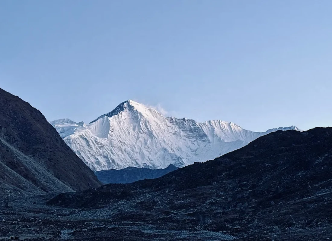
The Makalu Base Camp Trek is Nepal’s most complete answer for trekkers who’ve already done Everest or Annapurna and want something genuinely wild. Over 21 days, the route runs through the Makalu Barun National Park — the only protected area on Earth preserving an unbroken ecological corridor from subtropical lowland to an 8,000-meter summit — to reach the base of Makalu (8,485 m), the world’s fifth-highest mountain. While Everest Base Camp sees tens of thousands of trekkers annually, Makalu sees only a few hundred, and it shows in every mile of trail: no queues, no helicopter traffic, no crowded lodges, just genuine Himalayan wilderness and Rai and Sherpa villages largely untouched by mass tourism.
This guide covers every stop along the trail in detail, the extraordinary biodiversity of the Barun Valley, local culture and livelihoods, food and accommodation, altitude and acclimatization planning across two rest days, the best photography locations, essential gear, required permits, and honest answers to the questions trekkers ask most before committing to this demanding route.
| Detail | Information |
|---|---|
| Duration | 21 days (Kathmandu to Kathmandu) |
| Max altitude | 5,000 m (Makalu Base Camp area) / 4,870 m (base camp itself) |
| Makalu height | 8,485 m (world’s 5th highest) |
| Starting/ending point | Kathmandu (via Tumlingtar flight) |
| Trip grade | Challenging |
| Group size | 1–15 |
| Accommodation | Teahouse/lodge lower down; local shelter or tent above Khongma |
| Best seasons | Spring (March–May), Autumn (September–November) |
| Permits required | Makalu Barun National Park Entry Permit, TIMS |
| Guide | Strongly recommended, with a dedicated high-altitude support guide above Khongma |
| Ethnic communities | Rai, Sherpa |
| Key highlight | Standing at the base of Makalu’s pyramidal southwest face |
Kathmandu — Preparation and Cultural Orientation
The trip opens with two days in the capital: arrival, permit paperwork, and a guided tour of Swayambhunath, Pashupatinath, and Boudhanath. Because Makalu’s remote infrastructure means no last-minute gear shops once you’re on trail, this preparation window matters more here than on more developed routes.
Tumlingtar (400 m) and Num (1,560 m) — The Eastern Gateway
A short 35-minute flight from Kathmandu crosses into the Arun Valley, landing at Tumlingtar’s small airstrip in Sankhuwasabha district. A four-hour jeep drive climbs to Num, the last village accessible by road and the trek’s true starting point. Aerial views on the flight itself take in the eastern Himalayan skyline, including distant glimpses of Everest, Lhotse, and Makalu.
Seduwa (1,500 m) — Into the Arun Gorge
The trek begins with a steep descent from Num into the Arun gorge — one of the deepest river valleys in Nepal — before climbing back up through terraced farmland and subtropical forest to Seduwa, a traditional village with a small gompa and a genuine introduction to eastern Nepalese village life.
Tashi Gaon (2,100 m) — The Last Permanent Settlement
The trail continues along the Barun Khola through mixed forest to Tashi Gaon, a Sherpa village and the final permanent settlement before the high country begins in earnest. Beyond this point, overnight stops shift from village lodges to seasonal herder shelters.
Khongma Danda / Kauma (3,470 m) — First Acclimatization Stop
A steep climb out of Tashi Gaon through spectacular rhododendron forest (spring) opens into high pastureland at Kauma, a seasonal settlement used by yak herders in summer. This is the trek’s first dedicated acclimatization day, with short exploratory hikes recommended to ease into the altitude gain ahead.
Mumbuk (3,560 m) — Into High Alpine Terrain
A shorter but altitude-building day crosses glacial-melt streams from the upper Barun to reach Mumbuk, a seasonal camp used by both trekking expeditions and yak herders as the terrain shifts decisively toward high alpine character.
Yangle Kharka / Neha Kharka (3,700 m) — The Last Grassy Ground
The trail follows the upper Barun Valley across ridges and glacial streams to a high-altitude meadow camp — one of the final grassy areas before glacial terrain takes over completely for the remainder of the ascent.
Sherson (4,615 m) — Makalu’s Grand Reveal
One of the trek’s longest and most demanding days climbs through glacial moraine and rocky ridges to Sherson, a high camp on a wide glacial terrace offering a magnificent, unobstructed view of Makalu’s entire southwest face — considered one of the most spectacular mountain views in the Himalayas, since Makalu dominates its valley with a visual force that Everest, largely hidden by surrounding terrain at its own base camp, simply doesn’t match.
Makalu Base Camp (4,870–5,000 m) — The Destination
The final ascent crosses the moraine of the Barun Glacier to reach Makalu Base Camp, a flat glacial expanse ringed by Makalu itself, Makalu II (7,678 m), Chomo Lonzo (7,818 m), Baruntse (7,129 m), and — to the northwest — the Kangshung Face of Everest. Smaller groups often base out of Sherson and visit Base Camp on an early-morning excursion rather than camping overnight there, since an overnight stay requires tented equipment.
The Return Route — Pakuwa and Bumling
Rather than retracing the ascent exactly, most itineraries return via a slightly different path through Pakuwa and Bumling toward Tumlingtar, adding fresh villages and forest perspectives to the descent and completing what Alliance Treks describes as the “Makalu Circuit.”
Established in 1992, the 1,500-square-kilometer Makalu Barun National Park is the only protected area in the world preserving an unbroken ecological corridor from subtropical lowland to an 8,000-meter summit:
| Elevation Zone | Vegetation | Wildlife You Might Encounter |
|---|---|---|
| 400–1,500 m (subtropical) | Riverine forest, terraced farmland | Colorful lowland birds, langur monkeys |
| 1,500–3,000 m (temperate) | Dense rhododendron and oak forest | Himalayan black bear, red panda |
| 3,000–4,000 m (sub-alpine) | Birch, juniper, high alpine pasture | Musk deer, Himalayan tahr |
| 4,000 m+ (alpine/glacial) | Sparse alpine grass, moss, lichen | Snow leopard (rare), Himalayan griffon vulture |
The park’s biodiversity figures are genuinely exceptional for a single protected area: 47 mammal species, over 440 bird species, 75 orchid species, and 47 primula species — figures that place Makalu Barun among Nepal’s most ecologically significant trekking regions, alongside its role as a confirmed habitat corridor for snow leopards and red pandas.
The lower approach to Makalu runs through territory shared by Rai and Sherpa communities, an ethnic and cultural mix distinct from the routes further west. Villages like Seduwa carry a strong Rai character — animist-influenced spiritual practice, distinct language, and terraced-farming traditions — while Tashi Gaon, the last permanent settlement, is a genuine Sherpa village with Buddhist prayer flags, a small gompa, and cultural patterns recognizable from the Everest region despite the considerable geographic distance between them.
Because this region receives only a small fraction of the visitors that Everest or Annapurna do, daily life here continues with minimal tourism-driven adaptation — trekkers passing through are still a relatively unusual sight in Seduwa and Tashi Gaon compared to the routine, commercialized welcome found on busier circuits.
The Rai people, one of Nepal’s prominent Kirati indigenous groups, predominate in the lower Arun Valley villages like Seduwa, with livelihoods traditionally built around terraced agriculture, livestock, and — as with many hill communities — a history of Gurkha military service. Higher up, at Tashi Gaon and beyond, Sherpa families take over, following patterns of yak herding and high-altitude subsistence farming similar to their better-known counterparts in the Khumbu, though considerably less reshaped by trekking tourism.
Above Tashi Gaon, permanent settlement effectively ends — Kauma, Mumbuk, and the camps beyond are seasonal herding stations used by Sherpa families and yak herders during the warmer months rather than year-round villages, a livelihood pattern common across Nepal’s high alpine valleys.
Tourism income remains genuinely secondary here, given how few trekkers make the journey each year compared to Nepal’s headline routes. Most families in the lower valley rely primarily on farming, while portering and seasonal guiding provide supplementary income during trekking season rather than year-round employment.
| Food/Drink Category | Common Options |
|---|---|
| Breakfast | Tibetan bread, chapati, porridge, eggs, pancakes, toast, muesli, tea, coffee |
| Lunch | Dal bhat, noodles, fried rice, pasta, soups, momos |
| Dinner | A mix of Nepali, Tibetan, and continental dishes cooked with fresh ingredients |
| Hot beverages | Black tea, milk tea, ginger-lemon-honey tea, coffee |
Meals stay reasonably varied through Tashi Gaon, after which options narrow considerably in the seasonal shelters above — reflecting the genuinely remote, less commercially developed nature of the upper Barun Valley compared to Everest or Annapurna. Dal bhat remains the most dependable staple for sustained energy on the trek’s longer trekking days.
Reaching close to 5,000 meters at Makalu Base Camp, this trek takes altitude seriously, with two dedicated acclimatization days built into the itinerary — one at Kauma/Khongma Danda (3,470 m) and one at Base Camp or Sherson itself. The climb from Tashi Gaon (2,100 m) to Sherson (4,615 m) covers significant elevation gain over several consecutive days, making steady pacing essential.
Standard precautions apply throughout: ascend gradually, hydrate well, avoid alcohol at altitude, and report headache, nausea, or dizziness to your guide immediately. Given the trek’s genuine remoteness — no road access, no nearby helicopter landing infrastructure at base camp — a dedicated high-altitude support guide accompanies trekkers through the upper Barun sections, and mandatory travel insurance covering helicopter rescue to at least 5,500 meters is a standard requirement rather than a suggestion.
| Location | What Makes It a Standout Shot |
|---|---|
| Tumlingtar–Num flight approach | Aerial views of the eastern Himalayan skyline, including distant Everest and Lhotse |
| Arun Gorge (Num to Seduwa) | Dramatic river valley depth, among Nepal’s deepest gorges |
| Tashi Gaon | Traditional Sherpa village architecture against forested hillsides |
| Rhododendron forest above Tashi Gaon | Vivid spring blooms lining the ascent to Khongma Danda |
| Sherson | Makalu’s full pyramidal southwest face, unobstructed and dominant |
| Makalu Base Camp | Glacial expanse ringed by Makalu, Makalu II, Chomo Lonzo, and Baruntse |
Sherson is widely regarded as the trek’s single best viewpoint — unlike Everest Base Camp, where the mountain is largely hidden by surrounding terrain, Makalu dominates the frame directly from this camp with a visual scale few other Himalayan viewpoints can match.
| Category | Key Items |
|---|---|
| Head | Warm hat, sun hat, sunglasses, neck buff, headlamp |
| Body | Thermal wear, trekking shirts, fleece jacket, down jacket, waterproof rain jacket, trekking pants, gloves, warm socks |
| Foot | Comfortable, broken-in trekking boots, lightweight camp shoes, quality trekking socks |
| Sleep & comfort | Sleeping bag rated for sub-zero temperatures, earplugs |
| Health & safety | Comprehensive first-aid kit, water purification, altitude medication if prescribed |
| Practical extras | Trekking poles, reusable water bottle, power bank, cash in small denominations |
Given the trek’s remoteness, Alliance Treks equips groups with tented camp equipment (sleeping, dining, toilet, and kitchen tents) for the upper sections, along with a first-aid kit, emergency oxygen, and a satellite phone for base camp and upper-camp communication — provisions not standard on more developed routes.
| Permit | Purpose |
|---|---|
| Makalu Barun National Park Entry Permit | Required to enter the national park |
| TIMS Card | Trekker registration and safety tracking |
Unlike Manaslu, Kanchenjunga, or Upper Mustang, Makalu does not require a special restricted-area permit, since the route doesn’t cross into a formally restricted zone — though a licensed guide remains strongly recommended given the trail’s remoteness and limited infrastructure.
It’s rated challenging, suited to trekkers with good fitness, prior high-altitude experience, and a genuine appetite for remote, sometimes poorly marked trails over 5–9 hour daily walks.
Base camp itself sits at approximately 4,870 meters, with the surrounding exploration area reaching closer to 5,000 meters.
Most itineraries run 18 to 21 days round trip from Kathmandu, depending on acclimatization days and the specific return route chosen.
The Makalu Barun National Park Entry Permit and a TIMS card are required. No special restricted-area permit is required, unlike Manaslu or Upper Mustang.
It’s not recommended for complete beginners, given its long walking days, remote trail conditions, and high maximum altitude.
Makalu sees far fewer trekkers than Everest Base Camp, largely due to its remote access, longer duration, challenging terrain, and more limited accommodation infrastructure.
The Makalu Barun National Park supports red pandas, Himalayan black bears, musk deer, and rarely, snow leopards, along with a wide variety of Himalayan bird species.
Above Khongma Danda, accommodation shifts to basic local shelters or tents depending on the group and itinerary. An overnight stay directly at Base Camp requires appropriate tented equipment.
Spring from March to May and autumn from September to November are generally the best seasons, offering more stable weather, clearer mountain views, and better trail conditions.
The main Makalu Base Camp area is around 4,870 meters, while some surrounding viewpoints and exploration areas approach 5,000 meters.
Lower sections of the trek generally use teahouses and local lodges. Higher sections have more basic shelters and camping arrangements, particularly above Khongma Danda.
Essential items include layered clothing, a warm down jacket, waterproof outerwear, sturdy trekking boots, a sub-zero sleeping bag, trekking poles, sunglasses, sunscreen, a headlamp, water purification supplies, and a first-aid kit.
Yes. The trek reaches nearly 5,000 meters, so altitude sickness is a potential concern. A gradual itinerary, proper acclimatization, adequate hydration, and awareness of symptoms are important for a safe trek.
The Makalu Base Camp Trek doesn’t try to compete with Everest on fame or Annapurna on infrastructure — its appeal is the opposite of both. Long approach days, basic shelters above Tashi Gaon, and genuine trail solitude ask more of trekkers than Nepal’s headline routes, but the payoff is a nearly untouched wilderness experience and a direct, unobstructed view of the world’s fifth-highest peak that few other treks in the country can rival. For experienced trekkers seeking the real thing rather than a well-trodden bucket-list checkbox, this remains one of Nepal’s most rewarding expeditions.
Alliance Treks & Expedition Pvt. Ltd. has guided trekkers through Nepal’s remote Himalayan regions for over 34 years. For Makalu specifically, they provide NATHM-certified guides plus a dedicated high-altitude support guide for the upper Barun and base camp sections, porters carrying up to 20 kg each (one per two trekkers), and full tented camp equipment — sleeping, dining, toilet, and kitchen tents — for the high-altitude stretches beyond teahouse access. The package includes round-trip Tumlingtar flights, all park and TIMS permits, a first-aid kit with emergency oxygen, a satellite phone for upper-camp communication, and a returnable sleeping bag, down jacket, and duffel bag, with transparent group-based pricing.
Alliance Treks & Expedition Pvt. Ltd. Once is not enough for naturally and culturally Himalayas