(Viber, Whatsapp, Cell) +977 9851022814

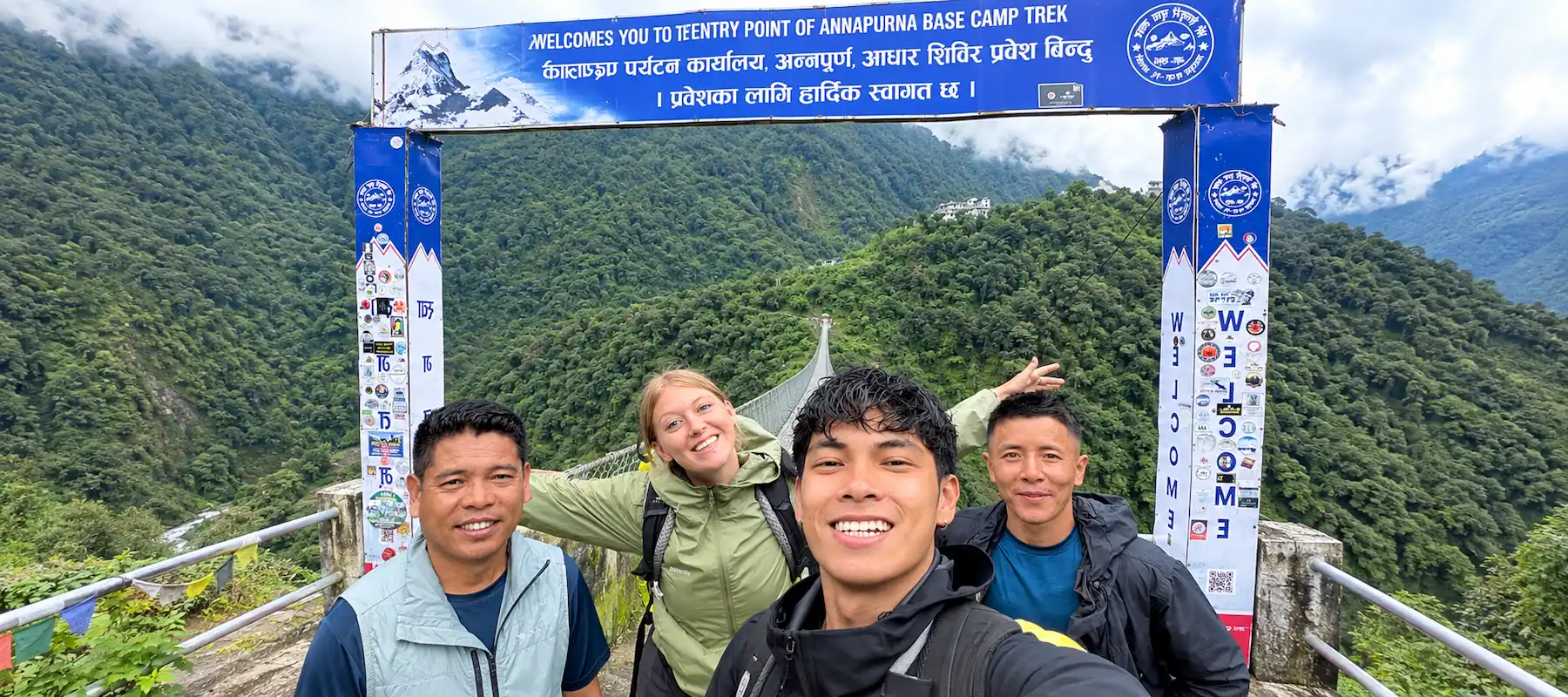
The Annapurna Base Camp Trek is one of Nepal’s most complete Himalayan journeys, packing forest, farmland, river valley, and high alpine terrain into a single week-long route. Starting and ending in Pokhara, the trail climbs from around 850 meters to 4,130 meters at Annapurna Base Camp, sitting inside a natural amphitheater ringed by Annapurna I, Annapurna South, Machhapuchhre, Hiunchuli, and Gangapurna. Unlike longer expeditions that demand weeks of commitment, this trek delivers a genuine high-altitude Himalayan experience — culture, wildlife, and mountain scenery included — in roughly seven days, which is exactly why it draws such a wide mix of first-time trekkers and seasoned hikers every season.
This guide goes beyond a basic itinerary. It walks through every stop on the trail in detail, the plants and animals you’ll encounter, the communities who call this region home, what you’ll eat, how altitude affects the trek, where to get the best photographs, what to pack, and which permits you’ll need — everything required to actually understand this trek before you commit to it.
| Detail | Information |
|---|---|
| Duration | 7 days (round trip from Pokhara) |
| Max altitude | 4,130 m (Annapurna Base Camp) |
| Starting/ending point | Pokhara |
| Trip grade | Moderate |
| Daily walking hours | 4–7 hours |
| Accommodation | Teahouse/local lodge, twin-sharing |
| Best seasons | Spring (March–May), Autumn (September–November) |
| Permits required | ACAP, TIMS |
| Ethnic communities on route | Gurung, Magar |
| Key highlight | Sunrise over the Annapurna Sanctuary from ABC |
| Day | Route | Max Altitude | Walking Time |
|---|---|---|---|
| 1 | Pokhara → Kimche → Chhomrong | 2,170 m | 4–5 hrs |
| 2 | Chhomrong → Dovan (via Sinuwa, Bamboo, Himalaya) | 2,600 m | 5–6 hrs |
| 3 | Dovan → Deurali | 3,230 m | 5–6 hrs |
| 4 | Deurali → MBC → Annapurna Base Camp | 4,130 m | 6–7 hrs |
| 5 | ABC → Bamboo | 2,310 m | 6–7 hrs |
| 6 | Bamboo → Jhinu Danda (hot springs) | 1,780 m | 4–5 hrs |
| 7 | Jhinu Danda → Kimche → Pokhara | 850 m | 3–4 hrs |
Nepal’s lakeside city serves as both the starting and finishing point of the trek. Sitting beside Phewa Lake with the Annapurna range visible on clear days, Pokhara is where trekkers pick up last-minute gear, meet their guide, and get their first real glimpse of the mountains they’re about to walk toward. It’s a noticeably more relaxed, slower-paced city than Kathmandu, and most trekkers spend at least one night here before and after the trek.
A short scenic drive from Pokhara brings trekkers to Kimche, where the actual walking begins. The road here winds through terraced hillsides and small roadside villages, and Kimche itself functions purely as a starting point — most trekkers pass through quickly, beginning the climb on stone-paved trails almost immediately.
Chhomrong is the last major permanent village before the trail pushes deeper into the Annapurna Sanctuary, and it’s often the first place trekkers get a real, close-up view of Annapurna South, Hiunchuli, and Machhapuchhre from the trail itself. Built across a steep hillside, the village is a genuine Gurung settlement with stone houses, terraced fields, and a long staircase descent marking the route onward — a physical and symbolic threshold between the inhabited lower valley and the wilder terrain ahead.
Beyond Chhomrong, the trail descends to cross the Chhomrong Khola before climbing back up through Sinuwa and into a long stretch of dense bamboo and rhododendron forest. Bamboo, named for the thick groves surrounding it, and the aptly named settlement of Himalaya are both small trail-stop villages rather than full communities — a handful of teahouses serving trekkers moving through this forested middle section of the route. This corridor is where the trek’s character shifts noticeably, from open terraced farmland to closed-canopy forest alive with birdsong and running water.
Dovan sits deeper in the Modi Khola valley, where the surrounding cliffs begin closing in and the forest starts thinning at higher elevation. It’s a quiet overnight stop with a handful of teahouses, notable mainly for how dramatically different the landscape feels compared to Chhomrong just a day earlier — steeper, narrower, and noticeably cooler.
Deurali marks the last stop before entering the Annapurna Sanctuary proper. Surrounded by towering rock walls and increasingly sparse vegetation, this is where the trail’s character becomes distinctly high-alpine. Deurali also sits close to Hinku Cave, a notable rock shelter along the route, and is typically where trekkers first feel the physical effects of altitude gain.
MBC sits at the base of Machhapuchhre (Fishtail Peak), a mountain considered sacred in local tradition and, notably, one that has never been officially summited out of religious respect. From here, the peak dominates the skyline at a scale that photographs can’t quite capture. MBC also marks the point where the Annapurna Sanctuary’s full amphitheater of peaks starts to reveal itself.
The trek’s destination sits inside a genuine natural bowl, surrounded almost 360 degrees by Annapurna I (8,091 m), Annapurna South, Hiunchuli, Gangapurna, and Machhapuchhre. Sunrise here is the trek’s signature moment — first light striking the surrounding peaks in sequence as the sky shifts from grey to gold. Most trekkers spend one night at ABC, giving time for both a sunset and sunrise viewing before descending.
On the return journey, Jhinu Danda offers one of the trek’s most welcome surprises: natural hot springs beside the Modi Khola river. After five days of walking, soaking tired muscles in these riverside pools has become something of a trekking tradition on this route, and most itineraries build in dedicated time here before the final descent back toward Kimche and Pokhara.
The trek passes through several distinct ecological zones as altitude increases, each with its own characteristic plant and animal life:
| Elevation Zone | Vegetation | Wildlife You Might Encounter |
|---|---|---|
| 850–2,000 m (subtropical) | Terraced farmland, sal forest, banana and citrus groves | Langur monkeys, various songbirds |
| 2,000–3,000 m (temperate) | Dense rhododendron, oak, and bamboo forest | Himalayan pheasants, red panda (rare sightings), Himalayan black bear |
| 3,000–3,700 m (sub-alpine) | Thinning forest, birch, juniper shrub | Musk deer, Himalayan tahr |
| 3,700–4,130 m (alpine) | Sparse alpine grass, moss, and lichen | Snow pigeon, occasional Himalayan griffon vulture |
Spring (March–May) is the standout season for flora specifically, when the rhododendron forests between Chhomrong and Sinuwa erupt into red, pink, and white blooms, transforming entire hillsides. The Annapurna Conservation Area, which the entire trek passes through, is Nepal’s largest protected area and plays a direct role in preserving this range of habitats.
The Annapurna Base Camp route runs directly through Gurung and Magar territory, two of Nepal’s prominent hill ethnic groups with distinct languages, customs, and long-standing ties to Gurkha military service. Villages like Chhomrong and Ghandruk (a common side-trip or alternate route village) showcase traditional stone-and-slate architecture that has remained largely unchanged for generations.
Local customs are woven directly into daily trail life — prayer flags and mani stones appear at village entrances, and many households maintain small shrines blending Hindu and Buddhist elements, a reflection of the syncretic spiritual practice common throughout Nepal’s hill regions. Trekkers passing through during Dashain or Tihar (autumn festivals) will often see villages actively celebrating, with kite-flying, tika ceremonies, and family gatherings visible directly from the trail.
The trail passes primarily through Gurung and Magar communities, both classified among Nepal’s Janajati (indigenous ethnic) groups rather than the traditional Hindu caste hierarchy. Historically, these communities have built their livelihoods around a combination of subsistence agriculture — terraced farming of millet, maize, and potatoes — animal husbandry, and, since the mid-20th century, foreign military service, particularly in Gurkha regiments of the British and Indian armies.
Tourism has become an increasingly central part of local livelihoods since the trekking industry developed in the region from the 1970s onward. Many families now run teahouses, work as guides and porters, or supply food and goods along the route, supplementing or in some cases replacing traditional farming income. This shift has brought visible benefits — better school access, improved infrastructure, more stable income — while communities have generally worked to maintain their cultural practices and village identity alongside the tourism economy rather than letting one replace the other.
Teahouses along the route serve a surprisingly wide menu, considering the remoteness of some stops:
| Food/Drink Category | Common Options |
|---|---|
| Staple meals | Dal bhat (lentils, rice, vegetables), fried rice, noodles |
| Western-style options | Pasta, pizza, pancakes, fried eggs |
| Tibetan-influenced dishes | Momos (dumplings), Tibetan bread, thukpa (noodle soup) |
| Hot beverages | Black tea, milk tea, ginger-lemon-honey tea, coffee |
| Snacks | Biscuits, chocolate, seasonal fruit where available |
Dal bhat remains the trekker’s staple for good reason — most teahouses offer free second helpings, making it an efficient, filling choice for a demanding day of walking. As with most Nepal treks, prices rise gradually with altitude, since everything above the trailhead has to be carried in by porter or mule.
At 4,130 meters, Annapurna Base Camp sits high enough that altitude is a genuine consideration, though the trek’s structure helps manage the risk better than many higher routes. Because the itinerary gains elevation gradually over several days rather than in one dramatic jump, and because the maximum altitude is lower than routes like Everest Base Camp, most trekkers experience only mild symptoms, if any.
Standard precautions still apply: ascend at a steady pace, stay well hydrated, avoid alcohol during the trek, and watch for early symptoms such as headache, nausea, or dizziness—report them to your guide immediately rather than pushing through. Because most 7-day itineraries don’t include a dedicated acclimatization rest day, choosing a guide who closely monitors the group’s condition each day is especially important on this route.
| Location | What Makes It a Standout Shot |
|---|---|
| Chhomrong | First clear, close-up view of Annapurna South, Hiunchuli, and Machhapuchhre from the trail |
| Bamboo–Dovan forest corridor | Dense rhododendron and bamboo forest, especially vivid in spring bloom |
| Deurali | Dramatic narrowing valley walls and increasingly stark alpine terrain |
| Machhapuchhre Base Camp | Closest, most dramatic angle on Fishtail Peak’s twin summit |
| Annapurna Base Camp at sunrise | The trek’s signature shot — first light hitting the full amphitheater of peaks in sequence |
| Jhinu Danda | Riverside hot springs framed against forested hillsides, a quieter, more intimate shot |
Sunrise at ABC is universally regarded as the trek’s best photo opportunity — arriving the evening before and waking before dawn is essential, since the light changes quickly across the surrounding peaks in the first twenty minutes after sunrise.
| Category | Key Items |
|---|---|
| Clothing | Moisture-wicking base layers, insulating mid-layer, waterproof outer shell, warm hat and gloves |
| Footwear | Broken-in waterproof hiking boots, camp shoes for evenings, wool trekking socks |
| Sleep & comfort | Sleeping bag rated for near-freezing temperatures, basic toiletries, earplugs for shared teahouse walls |
| Health & safety | Personal first-aid kit, water purification tablets or filter, altitude sickness medication if prescribed |
| Practical extras | Headlamp, trekking poles, sunglasses, sunscreen, portable power bank, cash in small denominations |
Many trekking agencies, including Alliance Treks, offer sleeping bags and down jackets on a free returnable basis, which reduces the amount of specialized cold-weather gear trekkers need to source or buy themselves before the trip.
| Permit | Cost (Approx.) | Purpose |
|---|---|---|
| Annapurna Conservation Area Permit (ACAP) | $20–$25 per person | Required to enter the Annapurna Conservation Area; funds conservation and local development |
| Trekkers’ Information Management System (TIMS) Card | $10–$15 per person | Trekker registration and safety tracking, subject to current government regulation |
Both permits are typically arranged directly by a registered trekking agency ahead of time, meaning trekkers usually don’t need to visit a government office themselves.
It’s a 7-day round trip from Pokhara reaching Annapurna Base Camp at 4,130 meters, passing through Gurung and Magar villages, forest, and high alpine terrain inside the Annapurna Sanctuary.
It’s rated moderate difficulty, involving 4–7 hours of daily walking and no technical climbing skill, making it suitable for reasonably fit beginners as well as experienced trekkers.
You need the Annapurna Conservation Area Permit (ACAP) and a TIMS card, both of which a registered trekking agency can arrange in advance.
Mild symptoms are possible above 3,000 meters, but the trek’s gradual elevation gain and lower maximum altitude compared to routes like Everest Base Camp make serious altitude sickness less common.
Trekkers may spot langur monkeys at lower elevations, Himalayan pheasants and musk deer in the mid-altitude forest zones, and occasionally Himalayan tahr near the higher alpine sections.
The main village stops are Chhomrong, Sinuwa, Bamboo, Himalaya, Dovan, Deurali, Machhapuchhre Base Camp, and Jhinu Danda, largely inhabited by Gurung and Magar communities.
Spring (March–May) offers blooming rhododendron forests, while autumn (September–November) offers the clearest, most stable mountain views — both are considered peak trekking seasons.
Yes. It’s widely considered one of the more accessible high-altitude treks in Nepal for beginners with reasonable fitness, especially when trekking with a licensed guide.
The Annapurna Base Camp Trek earns its reputation not from any single feature, but from how much it fits into a single week: subtropical forest, rhododendron bloom, Gurung and Magar village culture, a sacred untouched peak, and a genuine 8,000-meter mountain amphitheater at the end of it. It asks for moderate fitness and a reasonable respect for altitude, but no technical climbing skill — which is exactly why it remains one of the most consistently recommended treks in Nepal for travelers who want a complete Himalayan experience without a multi-week commitment.
With over 34 years of trekking and mountaineering experience since 1992, Alliance Treks & Expedition Pvt. Ltd. is a fully registered trekking company recognized by the Nepal Tourism Board, TAAN, and the Nepal Mountaineering Association. Our guides are government-licensed and trained in altitude awareness, first aid, and local culture, and itineraries are built around proper pacing and acclimatization rather than rushed schedules. With small group and private departure options, transparent pricing with no hidden costs, and a returnable sleeping bag and down jacket kit included, Alliance Treks handles the logistics so trekkers can focus on the experience itself.
Alliance Treks & Expedition Pvt. Ltd. Once is not enough for naturally and culturally Himalayas